
Billy Goat Trail
A word of warning: The Billy Goat Trail is not ironically named, like a giant man who’s called “Tiny.” True to its moniker, this path requires scrambling over rocks, and in places hopping from boulder to boulder, in a challenging trial of sure-footedness. But hikers have been braving this fairly strenuous trail since the mid-1800s, thanks to the stunning views it offers of cliff-lined Mather Gorge rising above the Potomac.
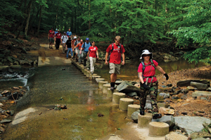
The 3.7-mile loop consists of 1.7 miles of clambering along the Billy Goat, and 2 miles of walking along the flat canal path to get there and back. To reach the trailhead, enter Great Falls Park on the Maryland side and park in the lot near the Great Falls Tavern Visitor Center. Cross the C&O Canal at the footbridge near the visitor’s center, then turn left and pass several canal locks. You’ll see the entrance to the Billy Goat Trail on the right, marked by blue blazes on the trees, just before you reach a second, high footbridge over the canal. Although the trail begins by winding through the trees, you’ll soon reach the rocks that give this route its character. There are plenty of places to stop and gape at the wild landscape —a view that suggests Alaska or Wyoming more than a spot just a few miles from the Beltway.
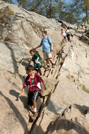 When the trail reaches the end of Bear Island, it rejoins the flat towpath, and you can stretch out your muscles on the easy walk back to the car. Be sure to wear hiking boots or sneakers for this hike and bring a water bottle—you’ll definitely work up a thirst. Dogs are not allowed on the trail, and it may be too difficult for children under 10. If you don’t choose to eat a picnic lunch while admiring the view, a cold beer and a crab slider can be found at the Irish Inn, about seven miles down MacArthur Boulevard. —Laurie McClellan
River Trail at Difficult Run Loop
If Maryland’s Billy Goat Trail sounds too strenuous, take heart: It has an easy-going twin in Virginia’s River Trail. This 2.8-mile loop leads to the same eye-popping views via a much kinder route that detours around boulders instead of hopping over them. Along the way, history buffs can stop and examine the remains of the Patowmack Canal, a pet project of George Washington’s.
To reach the trailhead, drive to the Virginia side of Great Falls and park by the visitor’s center. Look for signs to the Old Carriage Road and follow the gravel path, a historic road that once led to the community of Matildaville, for a third of a mile. Detour onto the Swamp Trail, where plank boardwalks rise above marshy sections of the trail. Many species of ferns grow along this shaded path, some of them rare.
 In eight-tenths of a mile, turn left onto the Ridge Trail and climb to a view of surrounding hills before turning left onto the star of the show, the River Trail. A rock formation just past this intersection offers the first view of the Potomac squeezing its turbulent self into narrow, cliff-lined Mather Gorge.
Keep an eye out for an old fireplace and chimney from Matildaville on this stretch of the trail, which is fairly flat and sandy, speckled with tiny, broken shells. The trail soon begins clinging to the edge of the cliff and detouring around rock formations, and the views of the Potomac get more spectacular the farther you hike.
This trail is suitable for kids and leashed dogs, but take care along the edge of the cliff, which hides some steep drops. Should you feel peckish when you reach the visitor’s center again, the snack bar sells guilty pleasures such as hot dogs, fries and Dove bars.
Feeling a bit more adventurous? Intrepid hikers can turn this trail into a 5-mile loop by hiking the River Trail first, then continuing onto the Ridge Trail and the Difficult Run Trail before returning via the Old Carriage Road. A section of the Difficult Run Trail is currently washed out, however, and some tricky rock scrambling is required to bypass it. This extended route also requires crossing busy Georgetown Pike on foot. —Laurie McClellan
Turkey Run Loop
 Don’t expect to see any wild turkeys trotting down this 1.75-mile loop trail; it’s named after one of the many streams—called runs—that flow beneath the George Washington Memorial Parkway and into the Potomac River. But what this trail might lack in gobbling, it makes up for in wildflowers, lovely river views and some streamside hiking along Turkey Run. This small patch of wild land is also the only place in Virginia where you can catch sight of the spectacled nettle moth.
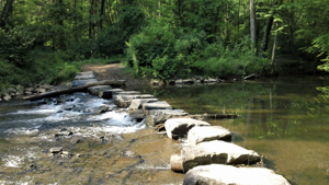
To begin this easy-to-moderate loop hike, park at the C-1 parking lot in Turkey Run Park, located on the George Washington Parkway in McLean, a few miles inside the Beltway. A sign in the parking lot points out the trailhead. Follow the yellow blazes as the trail descends, steeply in places, to the Potomac. When the trail forks, take the right fork to continue to the river. Despite the proximity of the parkway, the beech and oak woods here are surprisingly quiet and wild. When you reach the Potomac, turn left, enjoying the river views and, in spring, rafts of waving bluebells. In one-tenth of a mile, cross Turkey Run by hopping from rock to rock, and turn left to follow the loop. Walk along the stream, crossing it two more times. After the second crossing, follow the trail straight ahead and steeply uphill to return to the parking lot (do not walk under the parkway bridge).
Hikers who enjoy strolling along the Potomac can actually follow the river for eight more miles, from Turkey Run all the way to Roosevelt Island, on the Potomac Heritage Trail. Hiking boots are recommended for this trail, to keep feet dry in the muddy sections and the stream crossings. This is a popular trail for dog walkers and is suitable for children. —Laurie McClellan
Theodore Roosevelt Island
 Some hikes are all about solitude, while others are about community. On a warm-weather weekend at Roosevelt Island, expect to see runners whizzing past you, kayakers and rowing crews gliding by on the Potomac, and views of the busy Georgetown waterfront and the Kennedy Center. You’ll find families, young couples, and birders with binoculars. And dogs—plenty of them. But you won’t care. This densely wooded island, designed as a tribute to President Theodore Roosevelt, has so much to offer that you’ll be happy to share it with your fellow citizens.
This is not to say that you can’t also be alone on Roosevelt Island. The almost 90-acre island is large enough and has enough short side trails off the main loop that you can go for stretches without seeing another soul (side trails tend to be narrower, rootier and rockier than the main trail). Especially on the eastern side of the island, where a long boardwalk takes you through a boggy swamp and tidal marsh, the sights and sounds of the city fall away (except for the omnipresent airplanes ascending or descending overhead). Stop at a bench or an overlook and you may spot a blue heron or red-shouldered hawk perched on a branch.
 Although the thick woods appear as if they’ve been there forever, they’re actually the result of a massive Civilian Conservation Corps tree-planting project on the island in the 1930s. The island was first inhabited in the 17th century by the Nacotchtank Indians, who called it Anacostine Island. Later, it was known alternately as Analostan Island and Mason’s Island, with a plantation house and gardens built on the higher-elevation northern end by the son of Founding Father George Mason. Union troops occupied the island during the Civil War and briefly set up a freedman’s camp there.
By the early 20th century, the federal government had taken ownership of the land and turned it into a nature preserve, to honor the conservation-minded 26th president. A 17-foot statue of Roosevelt dominates a plaza at the center of the island.
After your hike, take the parkway north to Spout Run and stop at the Italian Store, a local favorite, for a slice, salad or sub. —Kim O’Connell
Scott’s Run
 If you’re all about business, the most direct way to hike Scott’s Run is to beeline to the stream, cross the stone pilings and then head straight to the waterfall and back again. You’ll be rewarded with a beautiful view and you won’t get lost (which is something that happens occasionally, even to hikers who frequent the trails that snake through this picturesque nature preserve in McLean).
Sandwiched between Georgetown Pike and the Potomac River, the preserve is a little less than 400 acres. Take the path along the Potomac or walk the ridge above it—though beware of drop-offs, especially if you are hiking with small children.
Other trails lead to rock outcroppings or to the ruins of the old Burling House, named for the family that once owned the property. After Edward Burling died in the late 1960s, his heirs tried to sell the land as a park. That plan fell through and the property was slated for development until a community outcry (plus a vote for a tax increase) led Fairfax County to purchase the land and pledge to keep it wild.
Today, wildflowers such as mayapple (so named because it blooms in May), Dutchman’s breeches, Virginia bluebells and bloodroot can be seen along the paths, while ducks bathe in the stream. The bustle of development isn’t far away—the stream actually begins near Tysons Corner—but it’s quite easy to pretend otherwise.
Bring a picnic lunch, plus a map or a friend with a good sense of direction. (Our 2.2-mile loop turned into a 3.6-mile hike when we ended up at the Langley Swim and Tennis Club by mistake.)
And remember to leave the wildflowers where they are. According to a county website, the preserve has had recent problems with poachers. —Madelyn Rosenberg
Pimmit Run
Pimmit Run might be described as the hiking equivalent of the “choose your own adventure” kids’ books in which readers (or in this case, hikers) make decisions that determine the plot’s outcome. You can follow Pimmit Run for miles, from the edge of Arlington through Fairfax County. The adventure level depends on where, exactly, you get on the trail. And there are plenty of entrances.
The downstream trail, which starts in Arlington near Glebe Road and Chain Bridge, shares space with the Potomac Heritage Trail for the first mile. It’s near here that the Declaration of Independence was reportedly hidden—briefly—in a grist mill during the War of 1812. Take a quick, eastern turn and a scramble over the rocks and you can see where the stream meets the Potomac, a favorite spot for anglers. Turn west to hike along the stream, and to cross it.
Though it’s not technically part of the Pimmit Run Trail, Fort Marcy (situated just across the Arlington line in McLean) has easy parking and is another good entry point with history: The fort was built in 1862 to protect Chain Bridge.
Follow the path downhill to the stream and head west. At times you’ll feel far away from it all, while at other points you’ll feel like you’re in someone’s backyard as the trail continues through McLean. Yet even in these residential areas—where you’ll meet more dog walkers than hikers—there’s plenty of wildlife. On a recent trip we spotted seven deer, a hawk, a water snake, loads of fish and what looked to be a heron. Plus, there were plenty of access points to the stream, which the kids preferred more than the path alongside it.
For the upstream trail, the easiest entrance to spot is the one at Kent Gardens Park—a point from which you can take the trail east, or head west toward Pimmit Hills, making your hike as long or as short as you want it to be. —Madelyn Rosenberg
Donaldson Run/Potomac Overlook Park
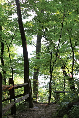
If you want to disappear into the woods without straying too far from civilization, Potomac Overlook Regional Park is the perfect place. Hidden at the end of a residential road in North Arlington, this heavily forested 70-acre patch of land was once a working farm that supplied produce to the District. Today, venture only a few steps in and you’ll forget you’re in an urban area.
Managed by the Northern Virginia Regional Park Authority, the park features several hilly woodland trails, punctuated by views of the Potomac River. The route is ideal for casual hikers, trail runners and families with kids who are old enough to handle the park’s narrow ridges and steep valleys.
Wildlife abounds here, including deer, coyote, frogs and salamanders. It’s a birders’ delight too, with red-bellied woodpeckers, hummingbirds, wood thrushes and even osprey in residence.
Children will get a kick out of the nature center, which includes exhibits and live animals such as a snapping turtle and snakes, only a short distance from the main parking lot.
A much closer view of the Potomac comes at the end of the Donaldson Run trail, which follows the park’s northwest edge (and is owned by Arlington County). This often wide, natural surface trail crisscrosses back and forth across the rocky run—watch your step or your feet will get wet—until it ends at the river's edge, where it connects with the Potomac Heritage Trail.
Although they’re relatively easy, the rock-to-rock stream crossings offer a sense of adventure for kids and adults alike. Don’t be surprised to find dogs off lead splashing in the stream and shaking off on the trail.
A side trail connects back to Potomac Overlook (look for the sign) if you want to make a day of it. And another partially paved section of the Donaldson Run trail picks up on the west side of Military Road and continues to Glebe Road.
After your hike, stop at the Lee Heights Shops on Lee Highway, where you can get a panini or salad at Cassatt’s Café or a cookie and coffee at Pastries by Randolph. —Kim O’Connell
Poison Plants
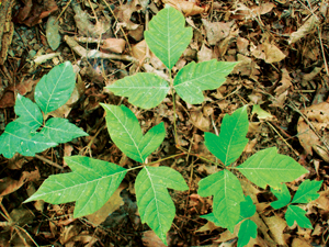 The Potomac basin includes a wide range of lush plant life, including poison ivy and poison oak, both of which grow close to the trails in certain spots. Keep your eyes peeled for poison ivy’s telltale glossy leaves, which grow in clusters of three per branch and can take the form of a vine or shrub. The leaves are reddish in spring, green in summer and yellow, orange or red in fall. Some plants have white berries.
Poison oak, a close cousin, grows as a low shrub marked by fuzzy green leaves in similar clusters of three. These leaves can be lobed or toothed with rounded tips. Some may have yellowish-white berries.
Blistery rashes are caused by the oil from both plants, which will linger on virtually any surface (including skin, clothing and pet fur) until it is washed off with water or rubbing alcohol. —Source: FDA Consumer Health
Our thanks to Eric Stern at Casual Adventure for recommending some of the hikes in this story. www.casualadventure.com